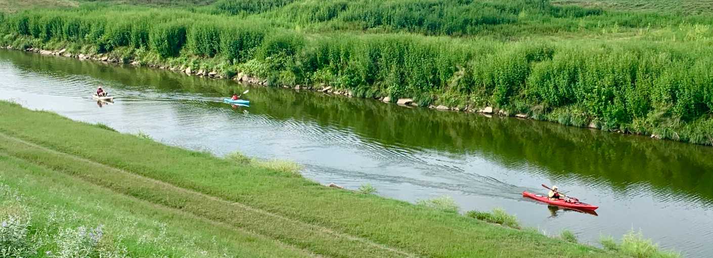
The Trinity is the longest river entirely contained within the state of Texas. You can explore the city’s main waterway via self-propelled navigation thanks to vendors like Backwoods Paddlesports who offer kayak, canoe and paddleboard rentals on sunny days or launch your excursion from several locations along the river.
A special thanks to the Tarrant Regional Water District (TRWD) for making river recreation a priority in addition to maintaining the Trinity Trails and riverside entertainment events.
Launch Locations
If you're looking to explore the river with your own kayak or canoe, there are seven self-launch locations in Fort Worth. In East Fort Worth, go just north of I-30 on Beach Street and park in the Rowing Club lot to access the launch site near Gateway Park. Head west to access the remainder of sites: two at Panther Island Pavilion, two off Trinity Park, one near Woodshed Smokehouse and one at the White Settlement Trailhead. Click here or view the image below for more info.
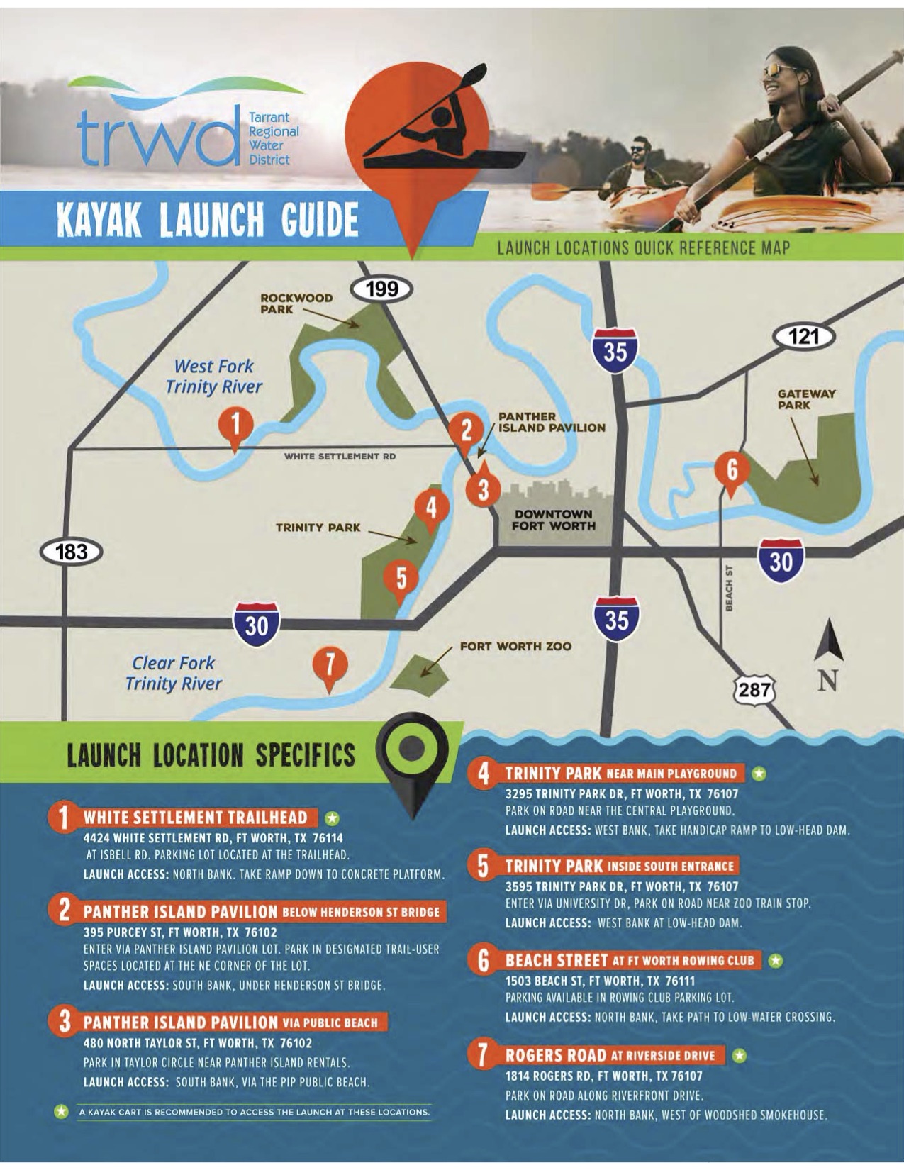
Panther Island Pavilion
The Pavilion is, in many ways, the hub of water recreation along the Trinity. If you’re looking to get outside and stay active but don’t already own a kayak, canoe, paddle board or pedal boat, you can rent one from Backwoods Paddlesports. They just added fishing kayaks, too.
Backwoods is open six days a week, which allows folks to escape to the river regularly for a day of social distancing. The sandy beachfront is activated daily as well featuring acoustic music sets, food trucks and more. With the pandemic in mind, the pavilion has added additional sanitization protocols.
The River
The Fort Worth stretch of the Trinity River is part of a larger paddling trail that stretches across 130 river miles, including nine cities and three counties. The Trinity Coalition has even submitted the Trinity Paddling Trail to the U.S. National Park Service for National Recreation Trail status - the national register of water trails.
The river’s footprint is literally alive with scenery. You might see red-tailed hawks, red-shouldered hawks and American kestrels gliding above as they try to zero in on a tasty field mouse below. Multiple species of egrets and herons migrate through the area and you’ll spot mallards and wood ducks sharing the water’s surface with you. Red-eared sliders and snapping turtles sun themselves as domesticated dogs drag their owners along the trails. In addition to fauna, the river’s water sustains plenty of flora. The most prominent are the trees. Viewable species include burr oak, pecan, cedar elm, green ash, cottonwood and black willow.
The Scenery
Your trek down the Trinity River will also take you around historical sites. The river was a hub for Native Americans for centuries before Ripley Arnold founded Fort Worth along its banks (Arnold has a statue near Panther Island Pavilion in the John V. McMillan Plaza). Some other landmarks to eyeball as you paddle:
- Paddock Viaduct Bridge (North Main Bridge): This structure connects downtown to the city’s North Side and the Historic Stockyards. It was considered highly innovative when it was built in 1914 and is still a vital piece of infrastructure.
- Fort Worth Power & Light Co. Plant: This art deco building commands the bluff overlooking Panther Island Pavilion. Built in 1912, it once provided power to the city.
- Tarrant County Courthouse: You’ll spot this 1895 landmark at the top of the hill as you pass downtown.
- Samuels Avenue/Rock Island Neighborhood: Just north of downtown, catch a glimpse of some intriguing vintage houses overlooking the river. These make up one of Fort Worth’s oldest neighborhoods, formerly home to some of its most historically prominent citizens.
- Fort Worth & Western Bridge: As you pass through Trinity Park, you might spot freight trains still passing over this early 20th century landmark.
Safety First
Keep dams in mind when you’re planning your route. Dams in general can be hazardous and portaging around them is recommended. Check the maps provided by the Trinity Coalition when you’re thinking about your trip down the river. Flooding after heavy rains can occasionally put some spots out of commission. The Trinity Coalition generally posts updates on their website when launch locations become unavailable.
-

Cycling Tips and Tricks for the...
Plan an excursion of Fort Worth’s Trinity Trails.
-

12 things to do along the Trinity...
Let the Trinity River be your guide with these fun activities along Fort Worth's Trinity Trails! 1....
-

Parks Off-The-Beaten Path to Visit...
Staying active outdoors is important to our overall physical and mental health during this time -- all...